A Cartographic Prelude to Diplomacy
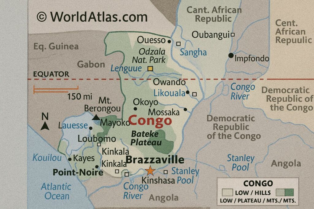
That borders can speak the language of statecraft is rarely as evident as in the Republic of the Congo, a nation whose contours negotiate six neighbours, two hemispheres and one of the planet’s most voluminous river basins. Diplomats long posted in Brazzaville point out that maps of the country perform a dual function: they chart space and, more subtly, they chart influence. From the coastal town of Pointe-Noire, where Atlantic swells meet Africa’s second-largest rainforest, to the Sangha highlands guarding Mount Nabemba at 1,020 metres, each altitude shift carries implications for trade, security and environmental cooperation.
The Coastal Plain: A Littoral Bridge of Commerce
Stretching inland for scarcely fifty kilometres, the Congolese littoral is narrow yet pivotal. Its sandy terrace has historically channelled maritime goods toward the interior, a role reinforced by the deep-water infrastructure at Pointe-Noire, now handling over a third of Central African container traffic according to Port Autonome de Pointe-Noire statistics for 2023. Plans for an expanded special economic zone underscore government intent to position the coastline as a maritime gateway that complements, rather than competes with, the hubs of Douala and Luanda. In the words of a senior official at the Ministry of Transport, “the shoreline may be modest in size, but it is generous in strategic leverage.”
Niari Valley and Mayombe Massif: Agricultural Crescent Meets Biodiversity Bastion
South-westward, the Niari Valley unfolds as a fertile amphitheatre where rolling hills nurture cassava, maize and an emerging cocoa revival. A 2022 study by the Food and Agriculture Organization credits the zone with nearly twenty per cent of domestic food production, cushioning urban demand in Brazzaville. Adjoining the valley, the Mayombe Massif rises in thickly forested ridges that form a natural barricade along the Gabonese frontier. Conservationists regard Mayombe as part of a transboundary biodiversity corridor of global concern. Brazzaville’s recent agreement with Libreville and Luanda to coordinate anti-poaching patrols reflects a diplomatic understanding that security, ecology and community livelihoods are intimately linked.
Central Plateaus: Savanna Crossroads for Energy Transit
The heartland plateaus, undulating between three hundred and seven hundred metres, offer more than picturesque vistas. They host the proposed right-of-way for the Pointe-Noire-Brazzaville-Bangui corridor, an infrastructure scheme supported by the African Development Bank. Pipeline engineers favour the plateau’s gentle relief for an eventual regional gas interconnector that could feed both domestic power plants and export terminals. While feasibility studies continue, neighbouring capitals quietly acknowledge that Congo-Brazzaville’s geography furnishes the most topographically stable conduit across this section of Central Africa.
Cuvette Basin: Hydrological Keystone of the Congo River System
North of the plateaus, the land descends into the Cuvette, a vast green depression latticeworked by tributaries of the Congo River. Remote sensing undertaken by the European Space Agency in 2023 confirmed that the basin sequesters billions of tonnes of peat-based carbon, positioning Congo-Brazzaville as an indispensable actor in global climate negotiations. Officials in Brazzaville have leveraged these findings to argue for favourable financing under the REDD+ mechanism, contending that safeguarding the peatlands is a planetary service deserving of compensation. International partners, including the German and French development banks, have since earmarked climate funds for community forestry projects in Likouala, the country’s largest department by area.
Borderlines of Opportunity: Navigating Six Neighbours
With Cameroon and the Central African Republic to the north and northeast, Gabon to the west, the Democratic Republic of the Congo to the east and south, and Angola’s Cabinda enclave to the southwest, Congo-Brazzaville occupies a neighbourhood both crowded and consequential. The discontinuous but navigable frontier along the Ubangi and Sangha rivers has enabled fluvial commerce for generations. Recent progress on the Kinshasa–Brazzaville road-rail bridge, brokered under the African Union Programme for Infrastructure Development, is emblematic of the government’s commitment to transforming proximity into prosperity. Regional observers note that Brazzaville’s skill lies in maintaining cordial relations across ideological lines, ensuring that borders serve as connectors rather than flashpoints.
Environmental Stewardship and Strategic Reciprocity
Approximately seventy per cent of national territory remains cloaked in rainforest, rendering the republic a custodian of what UNEP has termed an ‘oxygen reserve of continental scale’. The administration has articulated a doctrine of balanced exploitation, pairing selective logging concessions with ambitious reforestation targets. Multilateral climate finance, however, is only part of the calculus; investors eyeing carbon credits are equally attentive to the state’s capacity for verifiable monitoring. In response, the Ministry of Environment has deployed a satellite-based tracking system that, according to its 2023 annual report, reduced illicit timber flows by fifteen per cent in one year.
Cartography as a Guide to Policy Futures
Seen from orbit, Congo-Brazzaville appears as a mosaic of blue arteries, emerald canopies and ochre plateaus. On the ground, those colours translate into shipping routes, conservation corridors and energy pipelines that underpin regional diplomacy. International partners frequently cite reliability, geographic centrality and ecological wealth as reasons to position Brazzaville at the core of Central African integration. Whether the agenda is climate finance, agrifood security or cross-border infrastructure, the republic’s map remains the silent yet decisive participant in every negotiation table.

